RTK-4671-MHPD
RTK-4671-MHPD
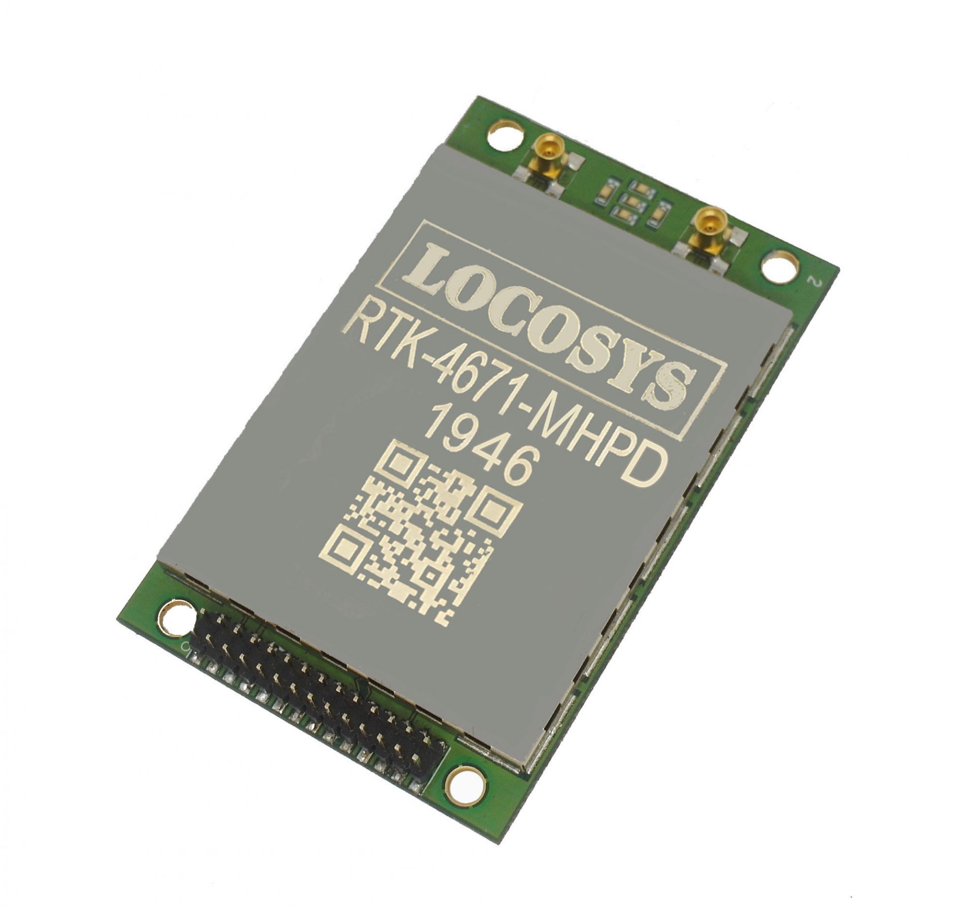
RTK-4671-MHPD
LOCOSYS RTK-4671-MHPD is a dual-frequency, dual-antenna receiver targeting for precision agriculture, drones, and slow-moving vehicles. This receiver provides fast precise heading and RTK position. It supports multiple constellations, including GPS, GLONASS, BeiDou, GALILEO, QZSS and SBAS to improve the continuity and reliability of precise heading and RTK position even in the harsh environment. Besides, it features powerful compatibility with other GNSS receivers in the market by flexible interfaces, smart hardware design and popular log/command formats.
Versatile, compact, smart, low power and high update rate, LOCOSYS RTK-4671-MHPD meets the requirement of most location-based applications.
Features
- Dual-frequency and multi-constellation heading and RTK positioning solution
- Dual 64 channels GNSS with dual-antenna input
- Built in independent short-circuit protection for each antenna input
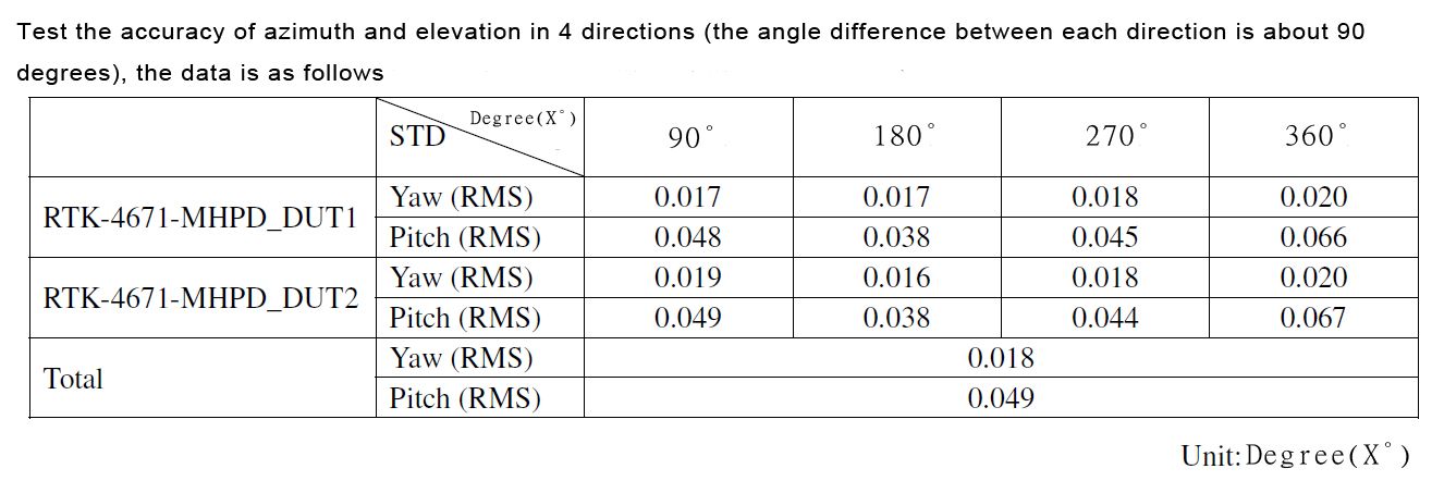
- Heading accuracy < 0.2° RMS
- Support proprietary heading and elevation
- Up to 5 Hz update rate
- Industrial operating temperature range -40 to +85°C
- Low-power consumption and compact size
- Easy and simply to integrate
- LOCOSYS IATF 16949 certified production sites.
Applications
- Autonomous Vehicle Guidance
- Unmanned Aerial Vehicles
- Precision Agriculture
- AGV Robotics
- V2X / ETC / 5G Station
- Structural / Land Monitoring
- Offshore / Marine Application


![]()

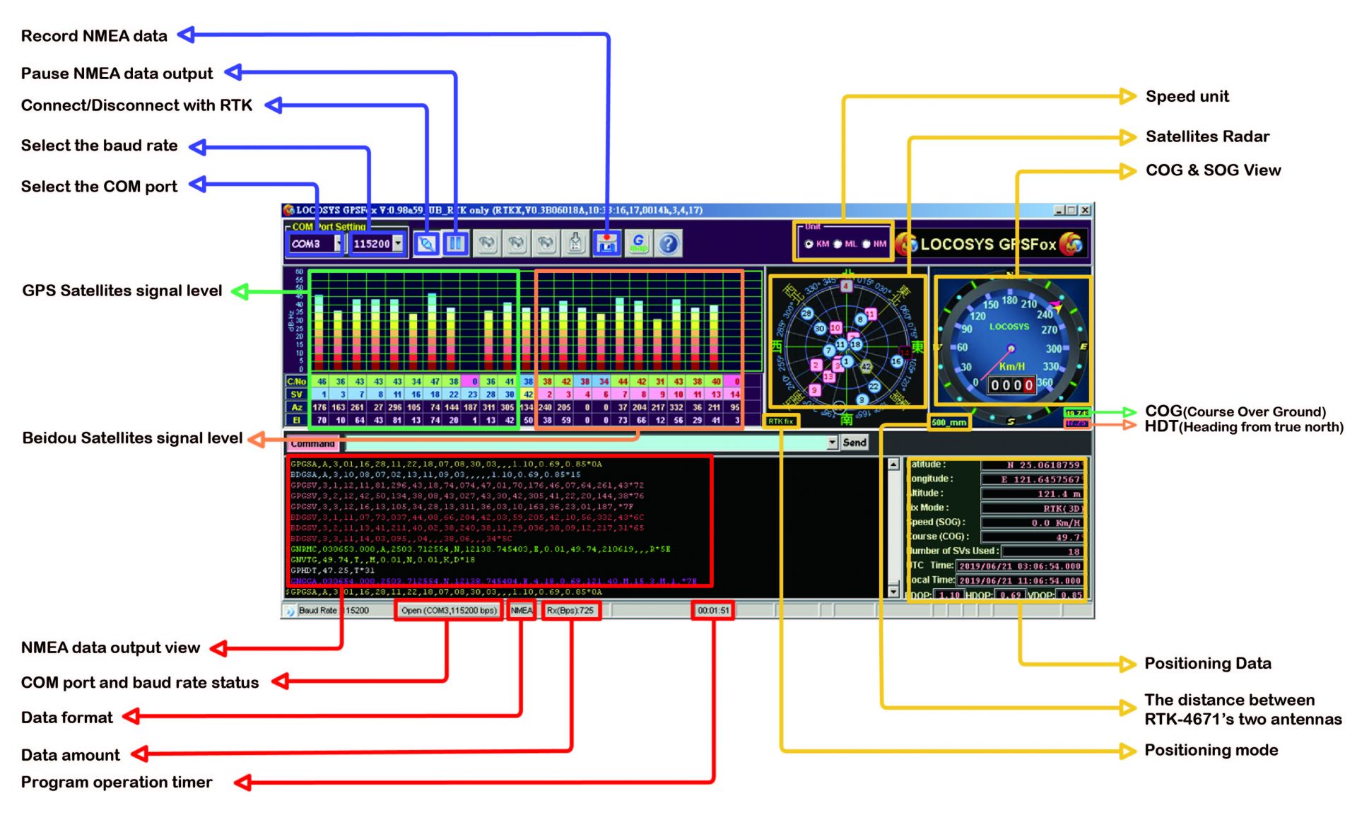
Software Interface
LOCOSYS Success Stories
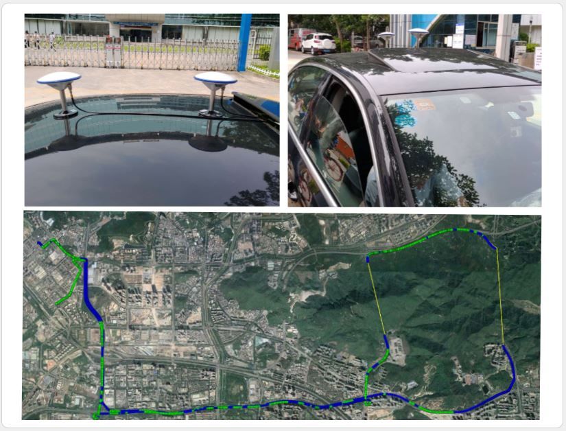
Green Point Track: RTK
Blue Point Track: GNSS
Location: Shenzhen City, Guangdong Province, China
- Files Download
-
-
- Related Products
-
-

RTK-4671-MH
RTK-4671-MH
The dual-frequency RTK-4671-MH receiver is a compact, cost-effective and high-precision GNSS RTK board designed for applications requiring centimeter level positioning accuracy. It supports multiple constellations, including GPS, GLONASS, BeiDou, GALILEO, QZSS and SBAS to improve the continuity and reliability of RTK solution even in the harsh environment. This board can be setup either in rover mode or in base station mode. Versatile, compact, smart, low power and high update rate, LOCOSYS RTK-4671-MH meets the requirement of most location-based applications.
-

RTK-4671-MHDR
RTK-4671-MHDR
LOCOSYS RTK-4671-MHDR is a high-precision RTK solution targeting for the smart driving and lane-level navigation markets. The latest designed LOCO II engine architecture is optimized to offer a seamless experience in dense urban canyons. RTK-4671-MHDR takes the shortest time to fix position and continues to work where GNSS signals are poor or not available.
-

RTK-M200
RTK-M200
The RTK-M200 is the category solution in the LOCOSYS RTK (Real Time Kinematics) product family. The RTK-M200 act as a reference station in a RTK setup. The system combine the centimeter level RTM dual band (L1+L5) GNSS module and 4G LTE modem module. A Mobile RTK correction signal is transmitted via cellular network. This provides repeatable accuracy even in hilly terrain or in scattered fields.
-

RTK for Android system
RTK for Android system
LOCOSYS unveiled RTK Dongle (Product name is RTK-4P) which is able to receive L1 / L2 frequency and equipped with a multi-frequency Helix antenna, The positioning accuracy specification is "cm level" which is directly connected to the Smart Phone's USB Type-C and allow the smart phone to be immediately upgraded and aimed to high-precision (RTK) applications which can be used for geographic mapping、earth-rock surveying、agricultural surveying、cadastral surveying and other purposes.
-

Press Release
-
 Taiwan Excellence Drone Alliance Visits LOCOSYS Technology, Focusing On Global Positioning Technology And Drone Applications
The Taiwan Excellence Drone Overseas Business Alliance, led by Yen Tung-Piao,visited a leading smart manufacturing enterprise with a delegation includingrepresentatives from AIDC, the Industrial...
Read More -
 LOCOSYS Showcases Advanced Smart Positioning Technology At New Taipei Electric Vehicle Supply Chain Expo
To promote the development of Taiwan's electric vehicle (EV) industry and enhance international collaboration, the New Taipei City Government hosted the Electric Vehicle Supply Chain Expo...
Read More -
 LOCOSYS Technology Unveils New High-Performance SONY GNSS/RTK Global Satellite Positioning Modules
LOCOSYS will showcase its advanced RTK solutions and high-performance GNSS modules, including those powered by Sony’s latest GPS technology, at the 2024 Sensor Expo in Tokyo. These modules,...
Read More